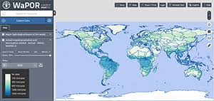
Water productivity data is now available to everyone with WaPOR v3
Detalles
Following its geographical expansion worldwide, WaPOR version 3 data is now publicly available at all levels. High-resolution data at 20 meters is also available for the entire Nile River delta.
The new portal offers a wide range of features that aim to provide tools to users to get the most out of data, such as:
|
Recursos relacionados
9th Edition of the ESG Observatory
Georgeson and the Club for Excellence in Sustainability present a new edition of the "ESG Observatory", through which the main…

Getting Started with the TNFD’s LEAP Approach: Santander Peru Case Study
This case study provides an example of the tools, data, challenges, and steps that banks, particularly those in South America,…