Around the world, new systems are being pushed to help address the existential threats of climate change, biodiversity loss and land degradation. Understanding the planet's ecosystems is essential to taking effective action in the face of these challenges. But we lack fundamental knowledge about most ecosystems on a global scale.
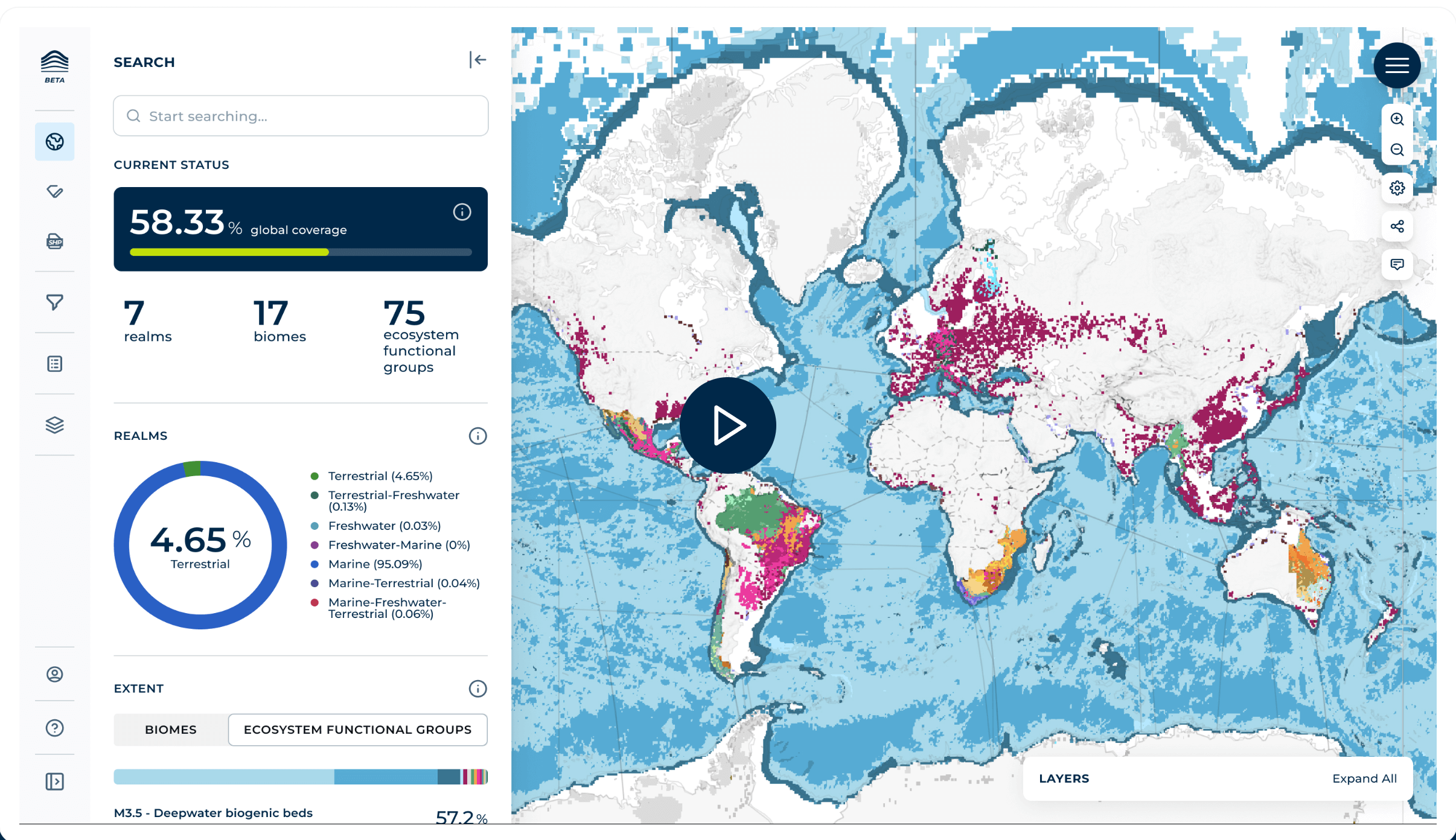
The Atlas of Global Ecosystems, developed by the Group on Earth Observations (GEO), is a collaborative cross-sectoral initiative to map and monitor the world's ecosystems, providing dynamic visualizations of natural environments, with which it seeks to close this gap. This will combine existing high-quality ecosystem maps with new maps created using the latest Earth observation technologies, artificial intelligence, field data and local expertise.
Who is the Atlas of Global Ecosystems for?- Policy-makers: They will have access to high-quality data on the extent, status and risks of ecosystems, enabling informed decision-making and effective conservation, restoration and environmental management policies.
- National Focal Points for International Conventions : They will have access to robust tools and datasets to streamline and improve reporting processes, ensuring accurate, coherent, and consistent compliance with international environmental frameworks.
- Private sector: Companies will be able to integrate the atlas into their business strategies to manage environmental risks, support sustainability goals, and improve corporate social responsibility practices and reporting. For auditors, the atlas will be an essential tool for verifying and validating a company's environmental statements and sustainability practices.
- Development banks and credit institutions, which will be able to use the atlas to assess environmental risks and guide sustainable investments, ensuring that projects are aligned with conservation objectives.
Local and indigenous communities: They will be able to use this tool to inform conservation and management measures for their lands by accessing detailed data on local ecosystems, combining traditional and scientific knowledge.
What does the atlas allow you to do?
The Atlas of Global Ecosystems is a versatile platform for identifying the distribution of different types of ecosystems, supporting conservation and restoration efforts, informing environmental management decisions, conducting research, and assisting in environmental and corporate reporting.
The functionalities of this resource facilitate the monitoring of the Global Framework for Biodiversity. In this sense, the MGB includes objectives to achieve the mission of halting and reversing biodiversity loss. Countries can use the atlas to access measurements and obtain information to help take stock, monitor and report on indicators of progress towards achieving ecosystem-focused MGB goals and targets.
The Atlas of Global Ecosystems has been created by collecting existing spatial data developed to represent ecosystems. These maps come from high-quality national, regional and global repositories. Each dataset has undergone a rigorous evaluation process, including validation and harmonization with the International Union for Conservation of Nature (IUCN) Global Ecosystem Typology, an internationally recognized system for classifying terrestrial, marine, and freshwater ecosystems.
|